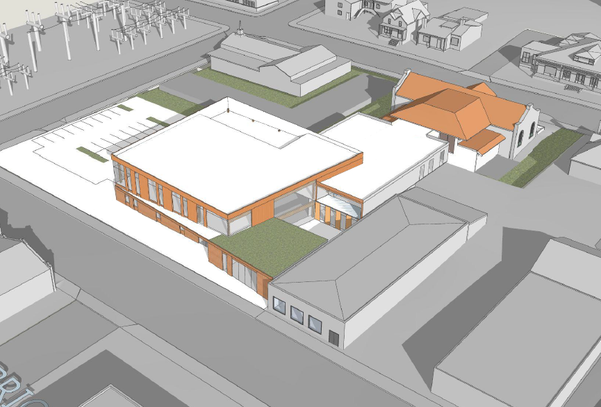
As you may know, the most recent Library Bond included a redesign of the Albina Library at 216 NE Knott St (property extends to Russell St). The Albina Library redesign process has been going on for over a year and their next meeting is September 8th at 6:00pm Zoom meeting (link).
here is a rendering from the Russell St side. More information and renderings in the slide deck below
You can see the slides they presented last Monday at the ENA Board meeting below.
During the pandemic, I have been doing a lot of reading about the history of my neighborhood, Eliot. I came across a number of plans from the 1960’s and 1970’s that affected inner North Portland. Joseph Cortright put together a 3-part series on how the Oregon Department of Transportation destroyed Albina, the biggest cultural center for Black Portlanders at the time. At the same time, Emanuel Hospital was expanded intentionally into the area between N Williams and N Kerby all the way to I-5/I-405. This was presaged by a short study called the Central Albina Study which recommended most of what is now the Eliot Neighborhood be demolished for Industry. Warehouses were recommended west of MLK Jr Blvd and South of N Fremont. This was later amended to west of N Williams avenue.
The history of our neighborhood is somewhat easy to find online if you know where to look. The Oregon Encyclopedia and Wikipedia have entries, and many articles are posted on our Eliot Neighborhood Association website. Then there is the Oral History Project, a series of interviews by the youth of northeast Portland talking to the elders of their community. One name that keeps coming up over and over is Paul Knauls.
Fire damage from Fire on September 11 at the Billy Webb Elks Lodge. Photo credit Restore Oregon
The following is a press release by Restore Oregon which includes the history of the Billy Webb Elks Lodge that sadly was the victim of a fire recently. The Eliot Neighborhood Association has donated funds to the Elks Lodge for restoration. We hope that others will join us in helping this organization restore the historic building that has meant so much to our neighborhood for so many generations.
An abundance of history and personal stories are woven into the fabric of Portland. So, to make sure the stories are not lost as generations of our residents pass on and memories begin to fade, here is one family’s story and a bit of history with links at the end of this article to learn more.
Irene Shaw Wilson’s home at 2747 NE 7th Avenue at the corner of Graham Street. Photo from Google Maps
For many of the Black residents of Eliot, the family stories begin outside of Oregon. The great migration from 1917-1970 brought both Black and white residents of the South to states in the North, Midwest, and West. Looking for an opportunity and a better life, many people landed in Oregon during the swell of migration during WWII because of the rise of shipbuilding and other war-related industries. With the influx of people moving to Portland, the city had to find a place for all these new residents to live.
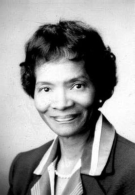
The Gladys McCoy Memorial on MLK and Knott. Photo credit Sue Stringer
At the busy intersection of Knott and Martin Luther King Jr. Blvd, a small semi-circle of grass with a few roses gives a break to the surrounding concrete. At the center of a faded, red brick wall is a portrait of Gladys Sims McCoy etched in stone, with wafted hair and bright eyes watching over passersby. McCoys’s smiling face is surrounded by an engraved list of her accomplishments, as well as the mindless graffiti tags familiar to underappreciated spaces of a city.
McCoy’s accomplishments were many. She was the first African American elected to public office in Oregon. She was elected to the Portland Public School Board in 1970. She also served for many years as a Multnomah County Commissioner. In remembrance, her name now graces a public park in Portland, public housing, and most recently, Multnomah County’s new downtown health department building.
Gladys McCoy – Photo courtesy Multnomah County
When she died in 1993 from thyroid cancer, her name wasn’t on any buildings, and her friend, Venerable Booker, wanted to ensure her legacy was remembered.
Booker was then the President of American State Bank, the first Black-owned commercial bank in the Pacific Northwest, which was located in the building directly north of the memorial, now a dialysis center.
A few blocks north of the bank, Hillary Mackenzie owned an architecture firm. As a customer of American State Bank, she got to know Booker well and was hired to design the memorial. She recalled he had a clear vision for the project, which would include “a walkway so you have to enter in the site, to settle in and read it. He wanted that recognition and then he wanted it to be pretty, so it was a place people would linger for a few minutes.”
McCoy’s portrait has recently had a front-row seat to many protests marching past in the wake of the murder of George Floyd. After the first night of protests in May, Irvington resident Kate Thompson went to survey the damage she had heard about on MLK. Across from the smashed Nike store windows, she found herself lingering at the memorial. “I walked past it for over a decade, walking to work at Good Sam’s,” she said. “It was not until I retired that I had time to be curious about its history’.
She started pulling weeds that day and has been returning most Friday mornings for the last three months. She has recruited others who wanted to help and started calling the group the Gladys’ Garden Gnomes. The garden has become a place for Thompson to channel her outrage of racial injustice into something positive. “We all need time for reflection,” she said. “Quack grass gives us that opportunity.”
For Thompson and her fellow volunteers, pulling up weeds provides an apt metaphor for our nation’s racism. The grass is deeply rooted and sends out runners in many directions, making it difficult to remove. Thompson acknowledges that she doesn’t know what good it will do, but that “it’s a choice to have hope.”
Thompson has been in contact with Mackenzie to add irrigation and some other features to the original design, including a way to memorialize Venerable Booker, the man who made sure our community knew Gladys McCoy’s life was a Black life that mattered.
Kate Thompson and the five arborists from Mossy Tree Care – photo courtesy Kate Thompson
Update: In October Mossy Tree Care donated their time to get the trees in shape which was very appreciated especially after the big windstorm. According to Kate Thompson, “Five men from Mossy Tree Care each donated two and a half hours of energetic labor to clean up the hardscape of the garden. They were a delight to work with.”
How I-5 was planned and built through Eliot in the 1950s and why we should not widen it
At a recent meeting, my Co-chair, Jimmy Wilson, asked me a pertinent question: “Where were white folks standing when Interstate-5 (I-5) was run through North Portland in the 1950’s?” I decided to dig through archives to find out, visiting the Oregon Department of Transportation (ODOT) website and then spending a significant amount of time on the Oregonian’s historical archive (found through Multnomah County Library). I also tried to find some other local news sources like the Northwest Clarion but unless I go find someone with an extensive microfilm archive and dig through it manually I don’t think I would find anything.
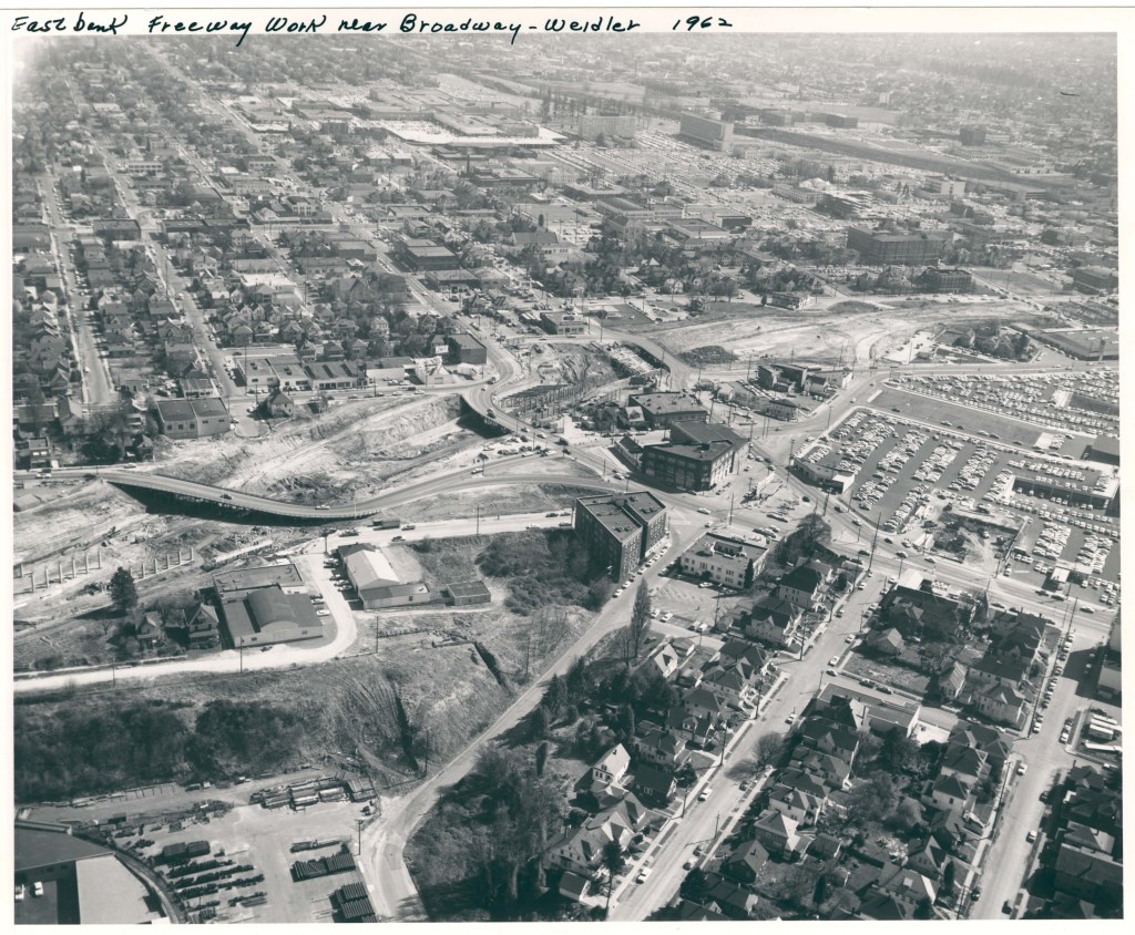
Eastbank Freeway Construction through the Broadway-Weidler Interchange in 1962. Photo courtesy Portland City Archives
In Northeast Portland, the intersection of Urban Renewal policies and Freeway Construction Policies combined to remove the heart of the Black community’s housing stock (over 800 units from the Eliot area alone) between 1955 and 1970. The Eliot and Lower Albina neighborhoods were decimated to make room for I-5, but even larger pieces were removed to make Memorial Coliseum and its parking lots. Later, Emanuel Hospital’s expansion dreams and the I-405 off-ramps removed even more of the community’s buildings and dislocated its people.
I was struck by the sheer pace of highway planning and construction during the late 1950’s through the Portland region. Planning or construction of all of the highways we now know within 5 miles of Eliot happened within 5 years. The roadway engineers had a seemingly limitless budget during those days, and they had tremendous power to reshape the city as well. They knew that highways became clogged with cars a few years after they were constructed through a process we now call “induced demand.” The highway engineers knew that I-84 (“the Banfield Freeway”) would soon become congested and had plans for a “Fremont Expressway” taking an east-west route through Northeast Portland and another “Mount Hood Freeway” taking an east-west route through Southeast Portland. Those routes will never be built, and from what I can tell, many of the existing highways should not have either. Uprisings over the removal of so many housing units prevented the later highways from being built, but not before Eliot and North Portland received the scar of I-5. These routes have served to increase the geographic footprint of our region and helped make everything more quickly accessible by car. In doing so, these highways have also increased the dependence on the car for transportation throughout our region, increased the average distance of trips and increased the basic cost of living of citizens of the Portland Metropolitan Region.
The Interstate System was funded through the Federal-Aid Highway Act of 1956 which authorized $25 Billion for the construction of 41,000 miles of the Interstate Highway system over a supposedly 10-year period. In the act, a Highway Trust Fund was created that paid for 90% of highway construction costs. This meant that state highway engineers could dream up huge plans and only needed a 10% match from local governments to build highways. This amazing subsidy may have helped highway builders of the time become desensitized to the value of the buildings they were destroying in the name of “progress.”
I found that there were other options considered for the “Minnesota Freeway” that we now know as I-5 from I-405 to the Washington border. However, the main other option was the “Delaware Freeway,” a route more along N Greeley and N Delaware Avenues, one which would have removed slightly more houses and been slightly more expensive to construct. This option would still have taken the same path through the Eliot Neighborhood. The opposition to the Minnesota option was disorganized and didn’t coalesce around one specific alternative, which contributed to it being ignored. There was a bridge built at N. Ainsworth across the highway to mollify the principal of Ockley Green School, which would have had its district separated by the highway had that bridge not been built. To this day N. Ainsworth is one of the calmest places to cross I-5 in north Portland.
After this research, I thought to myself, okay, what about the section of highway that actually runs through Eliot? It turns out that this was a bit challenging to find out about because it was actually considered a part of the “East Bank Freeway” even though this stretch between I-84 and N. Russell Street was not along the river. This route may have been chosen by planners at the City of Portland signing off on plans prepared by the Oregon Department of Transportation. From the news of the day, it appears that the people living and working on the east side of the river were not substantially consulted in the process, even though hundreds of families would be displaced for the highway project. The first mention of this highway running through Eliot in The Oregonian was from January 1959, and in February and March there were some articles talking about the number of buildings to be torn down. At one point they were referred to as “Ancient Buildings.” By December, the right of way had been cleared. This is unbelievable to me: Less than 6 months from the first timely public mention of the highway going through this area to the mayor approving the demolition, and 12 months from the first mention of the highway to complete demolition. A cursory note of the design of the Broadway, Williams, Weidler, Flint and Vancouver overpasses was made, as was a note that 29 other streets would be “terminated” or turned into dead ends.
During the demolition process, salvagers would pay prices as low as $5 for the right to salvage parts out of houses that would be demolished for the East Bank Freeway Route. One hundred and eighty households with 400 people were displaced by one count; another count I read included 250 households. Is it possible that those with the power to demolish buildings might not have been particularly concerned with those they were displacing? To me, this is obviously the case. One article I read talked about the shocking record of non-litigation by homeowners on the route. Either property owners thought they were getting a fair deal by the Oregon Department of Transportation, or they had no leverage in the courts to make it worth the legal troubles.
With the power of hindsight, we do not have to repeat the mistakes of the past. ODOT is planning to widen I-5 underneath the 5-bridge intersection we now have around Broadway, Weidler, Vancouver, Williams and Flint Avenues. During the 1960s, there were a series of highway revolts across the country, resulting in the National Environmental Policy Act of 1959 governing roadway construction. As a result of this, the current proposal by ODOT to widen I-5 around the Broadway/Weidler Interchange, rebuild all of the roads that cross the highway, and provide some minor and questionably valuable “ community benefits” has been in the planning and engineering process for the past 10 years. During the time since the planning process started, the process of “approving” this project has been orchestrated in a way that no elected body has had a simple vote on whether they wanted to build this project or not. There have been several votes about what type of environmental review process to do, about whether we want to pass a huge transportation funding bill including this project, and about whether to approve buying land for the right of way of the project. However, no politicians have ever been asked to vote on whether to actually build this project.
The project is not particularly popular. Roughly 90% of the public comments about the project have been in opposition to building it, including the Eliot Neighborhood Association’s comments at every step of the way. The effects of highway construction are generally worst for those that live and spend their lives closest to the freeway. The local residents are subjected to detours, construction noise and pollution during the construction process. In addition, after project completion, the increased traffic on local streets and the highway will make quality of life for those living around the project worse. That increased traffic is all but guaranteed while widening highways. There is a nearly 1-to-1 relationship between the number of highway lane miles and traffic, whatever name you give to the lanes that you are building. If we look closer at what “local benefits” the project would have, we can see that just tweaking the street grid above the highway will have minor impacts at best. A new pedestrian crossing between Winning Way and NE Clackamas street was intended to be an asset, but highway planners have put such a curve in it that it will not shorten any journeys with its meandering path above a noisy highway. The Hancock-Dixon overpass will not substantially connect streets that are not served with the current Flint overpass we have now. Even the new “public spaces” created by the project will be small and triangular, possibly the site of camping since no accommodation for productive buildings on them is being made.
The only real change the project would make to the surrounding area would be widening the highway, a car-capacity increase that will barely change travel times through the area. It would also serve to put more cars into our local street network, which has led to renderings showing even wider streets through the area than we have now. This would increase road noise and reduce the value of land around the project area. Although trumpeted as a “traffic and safety project” it serves neither. Safety on other ODOT-managed streets is a much higher priority than in this corridor, which has not seen any deaths in a decade. Only congestion pricing has proved to improve traffic in urban environments, and we should be pursuing that sort of system instead of putting down more concrete.
Before this project started, drawings of how to reconstruct I-5 in a wider configuration with “minimal” impacts to traffic above were generated. This project has always been about a wider I-5 through the Broadway interchange, and everything else is just window dressing. It is not too late. Any benefits this project might have could be achieved at a much lower cost through other means. We can still stop this $800 million boondoggle, which is clearly a continuation of the shameful history of highway construction in Portland’s inner neighborhoods. It is not too late.
Board Co-Chair Wilson’s heartfelt article in the last issue encouraged me to provide more perspective on his, and our neighborhood’s, experience with gentrification. Docks, railyards, and industries in Lower Eliot (now Lower Albina) provided jobs and Upper Albina (now Eliot’s residential area) provided housing for successions of groups seeking either, or both, refuge and a better life. The last wave was former, mostly black, shipyard workers fleeing the Vanport flood, many of whom were welcomed into the homes of former co-workers living in N/NE Portland. The lack of jobs and redlining stranded many of these in crowded, dilapidated homes. These conditions were a good fit for City leaders to looking for ways to stimulate economic development through “urban renewal.” The resulting renewal efforts and their impacts are well known; the Rose Quarter, PPS’s Blanchard Building, and Emanuel Hospital expansion. What is less recognized is the role Portland’s comprehensive planning and zoning practices played in facilitating gentrification.
State land use practice is controlled by Senate Bill 100 adopted in 1973 that was designed to slow urban sprawl. SB 100 required each county to develop, implement, and maintain plans and associated zoning that accommodates expected economic and population growth within an urban growth boundary (UGB). Industrial and residential development outside the UGB is severely limited. The expectation then, and now, is that future growth within the UGB will require increased density; smaller lots, multi-family buildings, and in-fill development.
Throughout the 1970s and 80s, Portland’s housing was predominately single-family, owner-occupied (roughly 65%) with the balance rental homes and apartments. The situation in Eliot was exactly the opposite; 65% rental and 35% resident-owned but in mostly single-family homes. Our population was equally distinct being one of the City’s most diverse and poorest. Although counties adopted land use plans based on long-range projections of population and economic growth, there was little of either during Oregon’s recession of the 1980s. The metro region’s population projection at the end of the recession was for an additional 1 million residents by 2040, of which Portland agreed to house at least half. To do so, it needed to change land use plans and zoning to squeeze those people into existing neighborhoods. Neighborhoods with a majority of homeowners naturally opposed any density increases in their neighborhoods. Consequently, City staff looked for poor, less well connected and organized neighborhoods to dump that density. Eliot loomed large as a target.
Controversy over the plan to dump density in inner N/NE neighborhoods forced the City to couch this change in the Albina Community Plan, adopted in 1993. The Plan paid lip service to the preservation of existing historic and affordable housing stock: however, the Housing Goal was to add 3,000 housing units by “increasing density … and increasing infill,” which it did by rezoning single-family lots for multifamily development. The Plan suggested new units would be constructed on vacant and under-developed lots; however, many of those lots were (and still are) vacant because of pollution and ownership questions making it impractical to repurpose them. Rezoning a home for potential multifamily use makes it more difficult to get a mortgage to purchase or rehabilitate a single-family home. As a result, the Albina Plan laid the foundation for gentrification through the conversion of older, but affordable, single-family homes to multifamily developments including townhomes and apartments, and a few McMansions.
The Plan also included an infill overlay to facilitate “granny flats,” which enabled two dwelling units on one, single-family home site. This encouraged the further loss of single-family homes and an increase in rental apartments. The Albina Plan was superseded by the new NE Quadrant Plan within the new Comprehensive Plan in 2016. Active engagement by the Eliot Neighborhood Land Use Committee resulted in zoning changes that concentrate increased density along Broadway, MLK, and Williams/Vancouver along with changes to residential zoning. This was intended to reduce pressure to demolish Eliot’s remaining, older homes. Unfortunately, after the plan was adopted the City changed the definitions of the new residential zones increasing pressure to convert lots with single-family lots into multifamily developments. In these days of heightened awareness of racial bias in institutional decisions, it is easy to conclude the zoning changes in Eliot were at least tainted by racism. That is difficult to conclude because the changes hide behind “policies” rather than individual decisions. Nevertheless, it is obvious white and wealthy neighborhoods avoided density dumping. Regardless, the City continues to assign blame for gentrification to the developers it enabled rather than acknowledging its role in that process. At a minimum, this reflects the City’s racial tone-deafness. One recent example of this is its “right to return” program that encouraged black residents to return to city-supported housing in Eliot. As several black leaders pointed out, this reinforces the public perception that Portland’s black population “belongs” in inner N/NE rather than in other, whiter neighborhoods. Another example is the proposal to put “lids” over the expanded I-5 freeway to “reconnect” the neighborhood. This ignores both the history of that area and its geography. I-5 in Eliot wasn’t carved out of a former residential area, it is below a bluff that is part of the Willamette River flood plain. In fact, as designed, the lid in Eliot will be primarily an overpass that is designed to connect truck traffic between Lower Albina and our residential areas via Hancock. In other words, it is a benefit for the trucking industry (as is the widening project itself) not the Eliot neighborhood or its residents, past or present. Hopefully, a new Council and the new racial awareness will finally result in policies that do not continue policies harming our community, starting with stopping the I-5 freeway expansion and, ideally, attacking vehicle pollution from the freeway and the rail and trucking industries in Lower Albina.
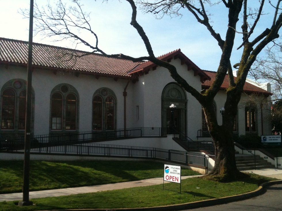
Multnomah County Library has declined to renew the lease for the current Albina Library location at 3605 NE 15th Ave. On July 1, the library will relocate back to its former location at 216 NE Knott St into a larger, historic Carnegie library building that currently serves as Title Wave Used Bookstore.
Title Wave Bookstore where the Albina library will relocate back to. This was the original location for this library branch.
This is unexpected and due to be a loss to many who have relied on the library in its current location. However, Eliot residents will probably be happy to have the library return to our neighborhood. Relocating any neighborhood’s library was not a decision that the Multnomah County Library staff took lightly. As Vailey Oehlke, Director of Libraries, stated in her letter to library patrons recently, “A variety of factors contributed to our decision, including this pandemic, which has caused us to make difficult choices and think in new ways about how the library can serve the community.”
Albina Library is the smallest branch in the Multnomah County Library system. Its current location is just 3,500 square feet. It doesn’t even have a public meeting room. The small space would not accommodate physical distancing which may be a necessary precaution for the foreseeable future. Therefore it would be likely that the space would allow only sidewalk service. However, the new location on Knott Street is about 2,000 square feet larger.
“The library’s lease of Albina Library expires on June 1, 2020. A three-year renewal would cost more than $260,000. As a steward of public resources, the library can’t justify that expenditure, when a suitable and larger option exists nearby that is already owned by the library,” stated Oehlke.
The new library will be 1.1 miles closer and easily accessible to both Eliot residents as well as not to far from the residents that were used to the Fremont and NE 15th Avenue location. The staff is working hard on getting the inventory relocated. If you have an item currently on hold at Albina Library the library will notify you about holds and pickups.
For information about the phased reopening plan, an FAQ and instructions for using the holds pickup service at other locations, please visit multcolib.org/covid19.
Until last summer, two Victorian houses, both built by a Black family, stood near the southern border of the Eliot neighborhood. Allen and Louisa Flowers built and owned these houses, which may have been the oldest standing houses built by Black people in Portland. The buildings had initially been part of a larger group of identical houses built by the Flowers family in 1885, but one of the other homes had been demolished in favor of a Ford owned parking lot in the 1970s. In an ironic example of history repeating itself, OB Portland Properties LLC – according to Portland Maps the same group that owns the land under the Broadway Toyota Dealership – bought and demolished the remaining houses in 2019. Presumably, these houses will also become a parking lot or some other car-focused infrastructure.
Although many of our cities’ streets and parks bear the name of previous residents, I hadn’t heard of the Flowers family until a neighbor mentioned that we were losing an important part of Portland history with these houses. Allen Flowers moved to Portland in 1865 after jumping ship from the Brother Jonathon where he’d been employed. Mr. Flowers became a porter for the Portland to Seattle route of the Northern Pacific Railroad and later married Louisa. Mrs. Flowers moved to Portland from Boston in 1882 after marrying Allen. At this time, Portland’s Black community numbered fewer than 500 members, which is not too surprising given contemporary politics. Oregon’s citizens included a Black exclusion law in their 1857 constitution, paving the way for Oregon to enter the Union in 1859 as a “whites-only” state. It wasn’t until 1959, that Oregon officially ratified the 15th amendment, allowing all people the right to vote, regardless of their race.
Ralph Flowers, son of Allen and Louisa Flowers, his wife Ruth Flowers and their son Clifford in front of the Flowers houses circa 1920. Photo courtesy of Oregon Historical Society
In this environment, the Flowers family built their version of the American dream. They maintained a farm near Mount Scott which became a hub for Black Portlanders and they were active members of their church. Allen Flowers developed NE Schuyler Street, supposedly to provide the only through street to the river for Louisa and their baby stroller. Louisa became a founding member of the Williams WMCA (now the Billy Elks Lodge) and active in the NAACP. The Flowers demonstrated leadership and compassion while living in a city that didn’t always welcome them. The Flowers family seemed like they would have been ideal neighbors.
The site of the former Flowers houses is designated as a Commercial Mixed-Use 3 zone. According to Portland’s Bureau of Planning and Sustainability, land with this designation should have buildings that are six stories high and are intended to be pedestrian oriented. For a civic minded family with a history of pedestrian improvements, increasing walking accessible housing seems like a potential extension of the Flowers legacy. However, since the current buyer’s portfolio includes a car dealership on the neighboring property, it isn’t likely that these sites will provide homes for new neighbors or pedestrian focused infrastructure.
After some thoughtful research, Home Forward, Portland’s housing agency, named its newest site the Louisa Flowers. Financed by low-income housing tax-credits, the building provides 240 affordable apartments and honors the impact that Mrs. Flowers had on Portland. Although the Flowers houses no longer exist in Eliot, The Louisa Flowers building continues the family’s work towards building a more welcoming Portland.
The Allen Flowers Houses 1803, 1811 1815 NE 1st Avenue, circa 1885. Photo courtesy of Oregon Historical Society
There were three small old houses inside our wonderful Eliot neighborhood that were demolished quickly last fall in a peculiar quiet fashion and not to the notice of most of our residents. Well, this rapid and hasty act appears to be deliberate and turns out to be a tragedy for our neighborhood and diverse cultural history. At this time, the author is not clear on the details of what happened on the west side of the block of NE 1st Avenue between Broadway and Hancock Streets on that late fall day back in 2019. What happened may not be the total blame to the developer and much of it rests on the City of Portland and their policies that severely lack an incentive for historic preservation. What is a bigger travesty is that these houses may only be replaced by a parking lot to serve the Toyota dealership on this block.
As of until recently, these 3 houses were owned by Pauline Bradford, a long-time resident of the Eliot neighborhood since 1945 who was very active for many years in the Eliot Neighborhood Association. She was a critical force in trying to make our neighborhood a better place for residents and made an impact on thwarting much adverse development. She was also one of the longest living African-American residents of our neighborhood and worked hard to help improve the living standards and rights of black residents. She also was a strong force in helping put together an inventory of buildings significant in African-American history back in the 1990s that was backed by the Bosco-Milligan Foundation (now Architectural Heritage Center). Known by the author for many years, she mentioned the many times that there were strong efforts by the property owners of the dealership (formerly Coliseum Ford) to pressure her and her husband in selling as far back as the 1970s. Sadly, since the 1970s, adjacent houses all around them were gobbled up as the building and parking lots were expanded. Now the entire block that goes west to N Victoria and north to Hancock may be completely in their ownership. It is not known if Mrs. Bradford recently passed away or relocated for health or other reasons. The last time the author made personal contact with her was in late 2017. The destruction was swift, and apparently, no parts of the houses were even salvaged or recycled. It is possible the owner(s) knew of the great historic significance of two of these houses as being associated with Allen Flowers, one of the first African-Americans who came to Portland and stayed. It is also tragic that the small houses could have been relocated in the general proximity at not too high of a cost due to their smaller size. Recent tax-break economic incentives by the Federal government to encourage rehabilitation of historic buildings would have made it sustainable and economically practical. There are many young ambitious homeowners to-be in the community and investors that would have been interested to save these houses and taken it on in short order. It could be that the new ownership acted on panic.
Now backing things up to the 1800s, Allen Flowers came to Portland in 1865 by jumping ship from a steamship where he was employed when it docked here. He managed to get by with many service-oriented jobs including the Lincoln Hotel in lower NW Portland for a number of years. Later, he became an operator for ships that delivered goods up and down the Columbia River and managed to secure a homestead in the Mount Scott vicinity. In 1884 and 85, he had a wife Louisa M. and purchased 2 lots in Elizabeth Irving’s First Addition of East Portland, now the block with the dealership on it. Interestingly at this early date, people of color were not excluded from purchasing at this location. He commenced construction of 3 houses, for his own new family and other relatives. Flowers chose this location due to his new occupation as a porter-in-charge for the Northern Pacific Railroad between Portland and Seattle. He remained in one of these houses for the remainder of his long life until 1934. He had 4 sons who also lived in these 3 houses with their families. One of his sons, Ervin M. Flowers remained and became the president of the NAACP during the 1920s. The entire family was very instrumental in improving the lives of black residents of Portland and their success in business and careers was also a motivating factor for encouragement to others.
At the present time, it is apparent that the two Flowers Houses that stood here were the oldest known in all of Portland that were black-built. In the historic photo taken just before 1900, all three are clear and very similar. Two of these remained until recently. It is a possibility that there could be a few other survivors of near the 1885 vintage in the general close-in North Portland proximity that are still unknown that could have been moved to other locations during the course of the 20th Century. So far, research has not produced anything known. It was discovered by the author back in the 1990s that the decorative Queen-Anne style cottage that stood at 1745 NE 1st Avenue was built in 1888 by James Curran in McMillens Addition to East Portland and moved to this spot in 1910 due to construction of an apartment building. McMillens Addition also allowed people of color and Chinese to purchase and build. That replacement building was torn down in 1960 along with many adjacent structures, for construction of Memorial Coliseum. Pauline Bradford lived in this house since 1979 and the interior was adorned with gorgeous woodwork and very tall ceilings and was in excellent condition. This was such a waste that we residents hope to never see happen again in our diverse neighborhood and a loss of a cultural resource that cannot be replaced. A tidbit from the book “The History of Albina”, available at Powell’s Books downtown and Broadway Books at NE 17th.
Another historic home may be on the move in Eliot soon. The property at 2316 N Vancouver has been sold and the Joseph M. Manning Cottage is slated for demolition unless it can be moved soon. The developer is open to the idea of moving the house and a few people who have an interest in the house’s future are working to make that happen. More in our summer issue on this, but for now, a little history about the home, built in 1892, from The History of Albina by Roy Roos.
Joseph M Manning cottage which is slated for demolition or relocation prior to development of a five story multi-family residential building. Photo credit Sue Stringer
“This Queen Anne cottage was moved to this location in 1949 and was previously located at 2307 N Flint, where now Harriet Tubman Middle School and Albina-Lillis Park is. Joseph M. Manning, the original owner and builder, was a street grading contractor. By 1898, he formed a partnership with William Lind as general contractors that lasted until about 1904. Manning independently returned to street grading which he continued until retirement. After this house was moved it was owned and occupied by Perry and Della Coleman. Mr. Coleman was employed by Union Pacific and African- American. After his death, Della remarried to Reverand Otha W. Warren, pastor of Mt. Carmel Missionary Baptist Church in 1962.”
By Jimmy Wilson, Co-Chair of Eliot Neighborhood Association
Having lived in this community all my life, which is 60 plus years, serving as co-chair of the Eliot Neighborhood Association, and being one of only three members of color in the association, it has become increasingly clear that my voice and presence is critically necessary as we seek to preserve our sense of community in an environment of gentrification and social change.
Jimmy Wilson, Co-Chair of the Eliot Neighborhood Association and longtime Northeast Portland resident
From my early years, as a kid living and walking the streets of my neighborhood, I have fond memories of the streets, parks, schools, churches, community centers, the families, the neighbors, the local grocery stores, the black-owned gas stations and auto repair shops that represented my community. At that time, over 250 black-owned businesses occupied North Portland from Mississippi, Vancouver, and Williams to Martin Luther King Jr. Boulevard. Looking back, I see how we took for granted the sense of a village and community we enjoyed.
Gentrification has brought about enormous changes some good and some not so good. Recognizing that change is inevitable in a community, the question becomes how is the change managed in such a way as to provide a balance between those who are new to the community and those who have been longtime members? Extremes in either direction are harmful to a healthy, harmonious community.
For many of us who have been longtime members, we fail to see the value in high-rise structures, traffic congestion, garbage on the streets, and an increased homeless population that we must address because it is a safety and health issue. We ask ourselves, what happened to the 250 black-owned businesses? What happened to the institutions, the cultural centers, the local hangouts, and other places where the community would meet? They are all gone! All except Dawson Park. What’s more, it is the failure to recognize the harmful effects of the forced displacement when gentrification occurs. For example:
· 10,000 black residents of the inner N/NE core have been removed over the last 15 years
· In 1970, 50-84% of N/NE neighborhoods were African American
· In 2010, only 18-30% of N/NE neighborhoods were African American
· In 1960, 4 out of 5 African Americans lived in the Albina area, and since 2000, less than 1 out of 3 African Americans live in the Albina area.
· The vast majority of our residents were uprooted by no choice of their own; but were systemically, forcibly displaced via an intentional, multi public sector plan to divest in the inner core while simultaneously making plans to reinvest and turn our neighborhoods into bastions of greater wealth for White Americans.
With this in mind, as Co-Chair of the Eliot Neighborhood Association, I have identified three primary goals as my priority in the association.
1) Create an environment of mutual respect and inclusiveness. This association must resist tribalism and understand that it represents the broad constituents in our community.
2) Be a proponent of equity. Our association must seek fairness, evenhandedness, impartiality, and justice. 3) Diversity. Our association board must vigilantly pursue the cultural variety and mixture of our community if we are to have legitimacy.
The City of Portland is in a sweet spot. There’s a ripe opportunity to redeem racist policies that destroyed Portland’s thriving Black community but whether city leaders will do the right thing remains unseen.
The Emanuel Displaced Persons Association 2, EDPA2 is an ad hoc community-based organization with membership comprised of survivors and Descendants of the Emanuel Hospital expansion forced removal. EDPA2 wants the City of Portland, Emanuel Hospital, Home Forward, formerly Portland Housing Authority, and Prosper Portland, formerly the Portland Development Commission (PDC) to do the right thing and return land they took from a majority Black community.
During the ’60s and ’70s, more than 70% of Portland’s Black residents lived in Central Albina. This was a problem for Ira Keller, then Director of PDC, concerned with the “high concentration of Negroes in Central Albina.” Utilizing eminent domain under Federal Urban Renewal Law, Prosper Portland and Emanuel Hospital demolished the houses and businesses in Central Albina. It was a contrived effort that involved the participation of a religious organization, local business, the City of Portland, the State of Oregon, law firms, financial institutions, title companies, electric company, elected officials and city leaders, prominent Portland families and an aggressive propaganda campaign to stoke fears of a “Negro Ghetto”. The City of Portland created a pamphlet and radio spot featuring an Ogre-like cartoon character called Creepy Blight whose sole purpose was to warn white residents of “Blight”. In 1967, the local NBC affiliate KGW produced a film titled “Albina: Portland’s Ghetto of the Mind”, The Portland Housing Authority, now Home Forward, exercised discriminatory housing practices like requiring a $20 deposit and monthly rent aimed at evacuees of the Vanport flood forced to relocate to Guild’s Lake. The Housing Authority also provided funding for the 1962 Central Albina Report used to justify and legalize the removal of Portland’s Black community from Central Albina. Prosper Portland created a pamphlet ameliorating the devastation caused by Urban Renewal and instructed residents on how to move!
In 1970, Black residents in Central Albina formed the Emanuel Displaced Persons Association, EDPA to combat the destruction of their community and to move “with dignity and without suffering financial loss” as stated in the 1949 Fair Housing Act. They filed a complaint with The Department of Housing and Urban Development, HUD. Finding merit with the complaint, HUD’s involvement forced Emanuel Hospital, The City of Portland, PDC (now Prosper Portland), The Portland Housing Authority (now Home Forward) and EDPA to sign a Replacement Housing Cooperative Agreement. The Agreement demands all parties to work together to replace every home that was demolished, a 1:1 replacement for the families forced to relocate. For close to 50 years various organizations and individuals have tried to encourage Emanuel Hospital to enforce the Agreement. To this day, the Agreement remains incomplete. Note: adhering to the legal stipulations of a Cooperative Agreement, The City of Portland adopted a policy preceding the Agreement to address the 1:1 replacement housing; the policy and Agreement were never implemented.
On August 1, 2017, City of Portland Mayor Ted Wheeler joined Executive Director of Prosper Portland, Kimberly Branam, and former President and Chief Executive Officer of Emanuel Hospital, Dr. George Brown, in a press conference to acknowledge racist policies responsible for the demolition and ultimate destruction of a once-thriving and self-sufficient Black community in what was Central Albina. Emanuel Hospital intentionally allowed portions of the demolished lands to “remain vacant for future development” for close to 50 years. A glaring reminder of a painful past for Portland’s Black community. Now, they claim to return a small parcel of land at the corner of N. Williams and Russell. For the record, Emanuel Hospital acquired more than 55 acres for their expansion yet less than an acre is offered for “return.”
To add insult to a longstanding injury, city officials claim the only way to develop the returned land is by placing it into the Interstate Urban Renewal Area, IURA. In the decade between 2000 and 2010, the IURA removed thousands of Black residents away from the city’s core in N/NE Portland where the majority of the city’s Black community used to reside. The IURA forced Black folks to relocate to east county, the poorest area in Multnomah County. The IURA is the largest, most gerrymandered and overused–it’s set to expire in 2021…
On August 9, 2017, at a regularly scheduled Prosper Portland meeting, members of EDPA2 and other community members stopped the vote to include the corner at N. Williams and Russell in the IURA. The vote goes before Prosper Portland’s Board of Directors again on March 11, 2020.
EDPA2 does not want the property at N. Williams and Russell included in the IURA where it’s expected to generate millions of dollars. How will the descendants of the Emanuel Hospital expansion receive any of those funds? EDPA2 wants city leaders to enforce and adhere to the Agreement that was signed many years ago. They want anything Emanuel Hospital and Prosper Portland “returns” to go to impacted families of the Emanuel Hospital expansion some of whose names are listed in the ten-panel historical display located in the Emanuel Hospital atrium. EDPA2 has met with City of Portland Mayor Ted Wheeler on this issue for more than 3 years. In December of last year, EDPA2 responded to the Mayor’s request for a plan with a presentation that includes long term economic development with a focus on community inclusion naming an internship program for neighboring students at nearby Harriet Tubman Middle School, job opportunities for high school students and a training/mentoring program for college students and ownership for Descendants of the Emanuel Hospital expansion. This plan is backed by an international company.
According to the August 1, 2017 press conference, it appears Wheeler and Branam want to relegate the Black community to affordable housing only, omit input from EDPA2 and deny long term economic development opportunities like the plan EDPA2 presented to the mayor.
On April 27, 2020 via zoom (rescheduled from March 31), EDPA2 aims to interject the omitted experiences and stories of impacted families into the current political discussion by presenting The Reclaiming Black Lands in the “Whitest City” lecture. Follow EDPA2 on Facebook. Contact EDPA2 at contactedpa2@gmail.com.
Join EDPA2 for Q&A Session for Reclaiming Stolen Black Lands in the “Whitest City”
Monday, April 27, 7–8:30pm on Zoom
Register here for the Q&A on Monday, April 27 at 7pm on Zoom,
Please read this summary in preparation for the Q&A
Watch this 6 minute documentary Urban Removal in Albina by the Lincoln Institute of Land Policy.
Many of our readers may remember the series of articles we have printed about the Martin Mayo House. You can find them on the Eliot Neighborhood Association website at eliotneighborhood.org. To recap, this Victorian house has had a very mobile history in our neighborhood moving three times to where it now stands at 236 NE Sacramento Street.
Back in the middle of 2018, the owners of the house were going to have the house demolished as they had sold the land to a developer who was going to build a new apartment complex. Enter, Cleo Davis, whose family has lived on the street since the 1980s. Just a few doors down to the east, where a little house sits at the back of the lot, is a piece of vacant land that once was occupied by an apartment building owned by Cleo’s grandmother. Unfortunately, the property, that was supposed to be income-producing for the family, was demolished in the late 1980s because of being deemed as blight.
Cleo is a local artist who was looking for a place to house the ARTchives which will focus on Black history in our neighborhood as well as other Black people who have made contributions to the community. When he saw that the house was going to be demolished, he went to work on buying the Mayo House, getting it moved down the street and then getting the property rezoned to accommodate businesses and residences. This was all accomplished by January of 2019 and the little house moved again, hopefully for the last time. It now sits on its new foundation awaiting renovation.
The history of the Davis family and the house move can be seen in a touching, short documentary called “Root Shocked” by Cecilia Brown, which can be found on Vimeo.
Most recently, potential ideas for renovations have been undertaken by the University of Oregon graduate students in the architectural program. Cleo co-instructed the course as students learned about the history of the neighborhood covering redlining and displacement. Then the students used the theories of spatial justice to draw up plans to build out the space using the existing Mayo House in the plans and provide community space and opportunities for displaced residents and artists. Each graduate student displayed creative uses of the space and house as final exam projects.
What the future holds for this historic home is uncertain as to the design and final architectural plans, but one thing is certain, this little house will not have to move ever again if Cleo Davis has any say in the matter. His grandmother can rest easy knowing that her property will be a place of community, provide financial security to her family and that future families will have a place to live that honors the past and provide bright opportunities for the future at the Martin Mayo House.